


Sept. 4, 2025
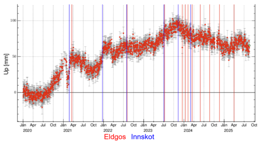
Uplift and magma accumulation beneath Svartsengi continues and the rate of accumulation has been steady in recent weeks. Model calculations estimate that around 6 to 7 million cubic meters of magma have accumulated beneath Svartsengi since the eruption that began on 16 July. The volume of magma released from the storage area beneath Svartsengi during that eruption is estimated at around 12 million cubic meters.
Based on experience from eruptions on the Sundhnúkur crater row, it is expected that the probability of a new dike intrusion and eruption increases once approximately the same volume of magma has accumulated beneath Svartsengi as was released in the previous event. Looking at the most recent eruption, this suggests that once 12 million cubic meters have built up again, the probability of a new event will rise. At the current rate of accumulation, this volume will be reached in the latter half of September.
An eruption should be expected, but its timing remains highly uncertain
It is important to note that the volume of magma released from Svartsengi in each eruption since March 2024 has varied considerably, ranging from 12 to 31 million cubic meters. It is therefore unwise to assume that the next event will behave exactly like the last one. The previous event may have been unusual in terms of how much magma had to accumulate beneath Svartsengi to trigger an eruption. Experience from recent events also shows that even small changes in the accumulation rate can shift the timing of the next possible eruption by several weeks. The uncertainty in timing is therefore considerable, and the current accumulation period could last longer than expected.
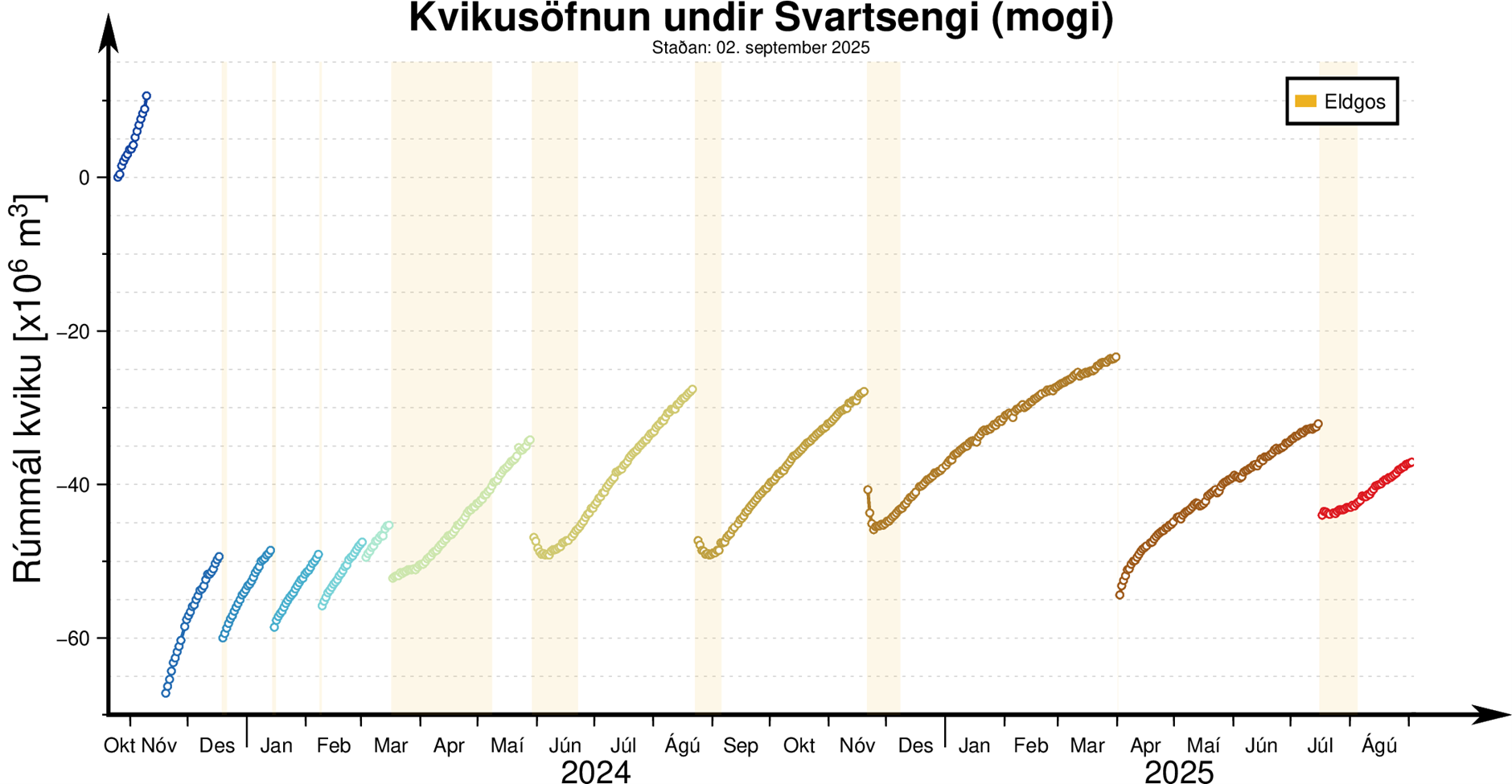
The figure shows the magma accumulation periods on the Sundhnúkur crater row since October 2023. From March 2024 up until the eruption in July 2025, the accumulation periods had been lengthening.
IMO's model calculations provide indications of when the likelihood of the next event may increase, but monitoring and preparedness plans are based on the assumption that an eruption could start at any time.
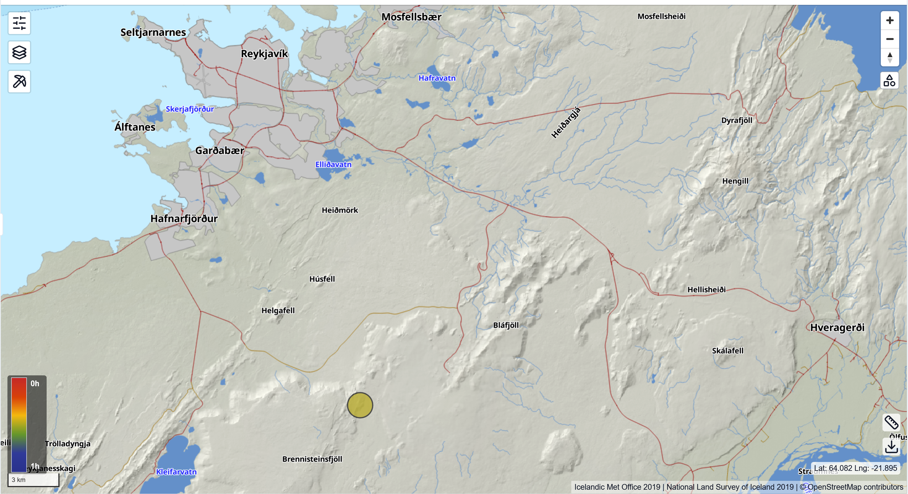
If an eruption does occur, the most likely source area is between Sundhnúkur and Stóra-Skógfell. Signs of an imminent eruption include microseismic activity and sharp deformation changes detected by fiber-optic and GPS instruments, as well as pressure changes in boreholes. The expected warning time before an eruption is short, as in previous events, ranging from 20 minutes up to just over 4 hours.
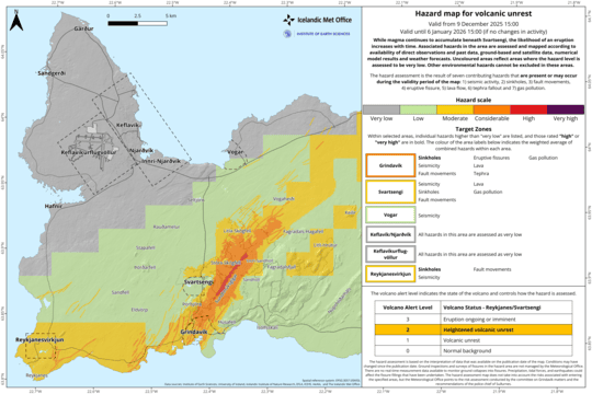
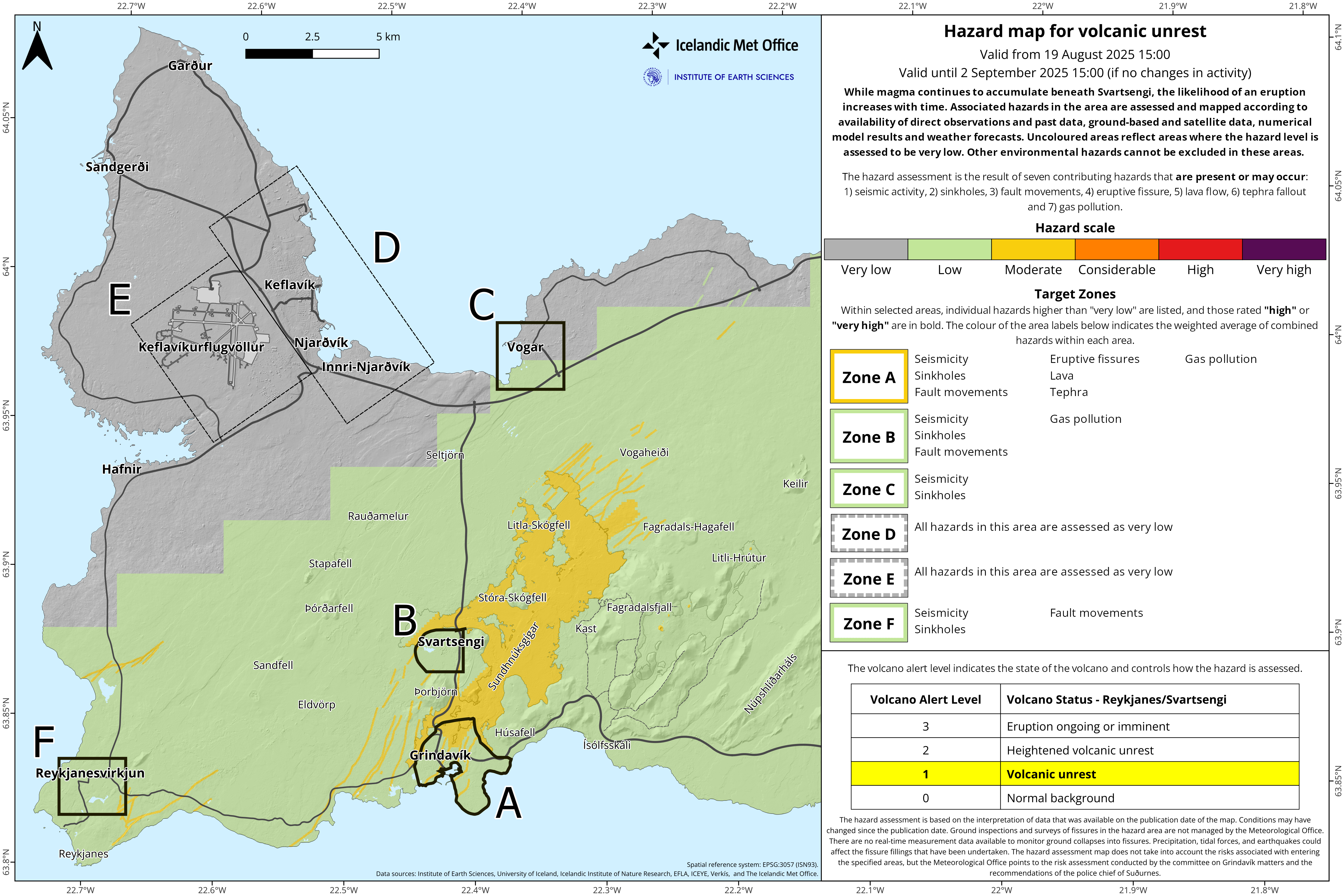
The hazard assessment has been updated and is valid until 16 September unless activity changes.
The main change from the previous hazard assessment is that the size of zone C (Vogar) has been revised. As a result, the hazard of ground collapse into fissures is no longer specified for this area. The new lava field remains in the category “some hazard” (yellow color).

Seismic activity continues west of Lake Kleifarvatn. Krýsuvík and nearby areas are historically known for seismic activity, but recent unrest is mainly related to triggered earthquakes from magma intrusions beneath Fagradalsfjall and Sundhnúkur. In Krýsuvík, land subsidence is now being measured. The area has previously shown fluctuations of uplift and subsidence related to the geothermal system and possibly magma movements underground, but since eruptions began near Svartsengi in July 2023 the subsidence rate has increased compared to earlier. Further analysis of the activity is underway, but there are no indications that magma is moving closer to the surface in Krýsuvík.
Previous update – 19 August 2025
Potential for larger earthquakes in Brennisteinsfjöll
Deformation detected in the Krýsuvík area
Ongoing uplift at Svartsengi
Hazard map updated
An earthquake measuring magnitude 3.2 struck southwest Iceland shortly after 18:00 yesterday and was felt in the capital area. The quake was located in Brennisteinsfjöll, an active seismic zone. Since the onset of activity on the Reykjanes Peninsula in 2020, seismicity in this area has increased, reflecting growing stress accumulation in the crust.
It should be noted that strong earthquakes recur in this region, although at long intervals, and it is uncertain when the next might occur. The last major events were M6.4 in 1929 and M6.1 in 1968. Since then, building standards have steadily improved with stricter requirements for earthquake-resistant design. While earthquakes of this size can trigger rockfalls in steep slopes and cause household items to shift, injuries in Iceland are rare and most often result from unsecured objects falling during shaking.
In earthquake-prone areas it is advisable to take preventive measures to reduce the risk of damage, such as securing heavy objects so they are not placed above beds, and reviewing guidelines on how to respond during earthquakes.
The epicenter of yesterday's earthquake in Brennisteinsfjöll. It measured M3.2 and was widely felt in the capital area.
Some seismic activity has also been recorded west of Kleifarvatn. Krýsuvík and nearby areas are historically known for earthquakes, but recent activity is mainly linked to intrusion-related quakes beneath Fagradalsfjall and Sundhnúkur. At Krýsuvík, both uplift and subsidence have been measured. The area has shown such fluctuations before, but the current deformation appears faster than previously observed. Further analysis is underway.
Experts are closely monitoring the situation, assessing data daily and communicating findings as needed.
Magma accumulation continues beneath Svartsengi at a rate similar to that before the last eruption. No seismic activity has been detected in the area since the eruption began.
Ground deformation
The figure shows vertical ground motion in Krýsuvík measured by the KRIV GPS station since 2020. In the first years, the land rose steadily, but since autumn 2023 it has been subsiding. Following the eruption at Svartsengi in July 2023, the subsidence has accelerated.
The record also shows regular fluctuations linked to magma movement underground. Since last summer, the subsidence has coincided with increased seismicity in the area, which is a normal response when magma shifts in the crust and redistributes stress.
For comparison, InSAR satellite images are used to measure small surface changes by comparing images taken at different times. These confirm the same pattern as the GPS measurements.
The hazard map for the area has been updated and is valid until 2 September unless conditions change. The main update is that the new lava field has been downgraded to the “some hazard” category (yellow), the same as older lava fields.

www.malaymail.com/news/world/2026/01/11/bomb-attac…
BANGKOK, Jan 11 — A series of late-night bomb attacks targeted 11 PTT petrol stations in Thailand’s southern border provinces of Narathiwat, Pattani and Yala…
www.khaama.com/at-least-eight-refugees-die-37-resc…

At least eight refugees died and 37 were rescued when their boat sank off Badmeli near Izmir, Turkish authorities said on Saturday.
katu.com/news/local/oregon-confirms-first-measles-…

Health officials in Oregon have confirmed the state's first measles cases of 2026, with two people diagnosed in Linn County.
abc11.com/post/measles-north-carolina-state-report…
Measles in North Carolina: State reports 5th case linked to South Carolina surge