Iceland Volcano: Ground Uplift Is Faster Than Before The Last Eruption 29 May -- Iceland Met Office
 From the Civil Defense patrol flight on May 9. No lava splashes are visible in the crater, although smoke continues to pour out of it. (Photo: Civil Defense)
Magma inflow continues into the Svartsengi reservoir and the likely timeframe for the next diking event and/or eruption is the coming weeks/months.
Updated 2. July at 17:00 UTC
- The uplift rate is now higher than prior the eruption which commenced on 29 May
- A magma volume of about 13-19 millions m3 left the reservoir when the last eruption started
- It is likely that the next diking event and /or eruption will occur in the coming weeks/months
- The hazard map has been updated
Since the end of the fifth eruption in the Sundhnúks crater row on 22 June, magma continues accumulating at depth beneath the Svartsengi region. Based on geodetic modelling results, the current recharge rate to the Svartsengi reservoir is estimated to be 4-6 m3/s. During the diking event on 29 May and the first week of the eruption, the estimated volume drop from the reservoir was 13-19 million m3. Current modelling results indicate that this total volume loss will be recharged to the Svartsengi reservoir within the next 3 to 6 weeks. As of today, this is the likely timeframe for the next diking event and/or eruption.
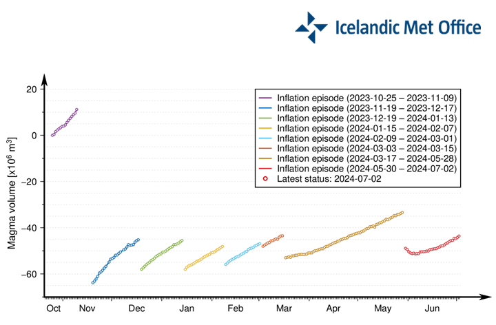 A graph showing the progression of magma accumulation and the estimated total volume of magma beneath Svartsengi between the series of intrusions and eruptions, spanning October 25, 2023 to present. The values presented are based on models using geophysical data. The red dots show the status since May 30, 2024.
A new hazard map has been published by IMO. Hazards associated with lava flow and gas pollution have been lowered in many zones. The overall assessment is unchanged except in two zones. The level of hazards within Zone 3 goes from high (red) to considerable (orange), and within zone 5, from considerable (orange) to moderate (yellow).
 (Click on the map to see it larger)
- CategoriesEdited | Front Page Stories | All Content | Disasters | Earthquakes | Volcanos | Government | Science | Europe | Atlantic Ocean
- Date rangeTuesday, July 02, 2024
- Last modifiedThursday, June 04, 2026
